Music first: https://www.youtube.com/watch?v=qwLmqWnZU40 Ma Nouvelle Orléans
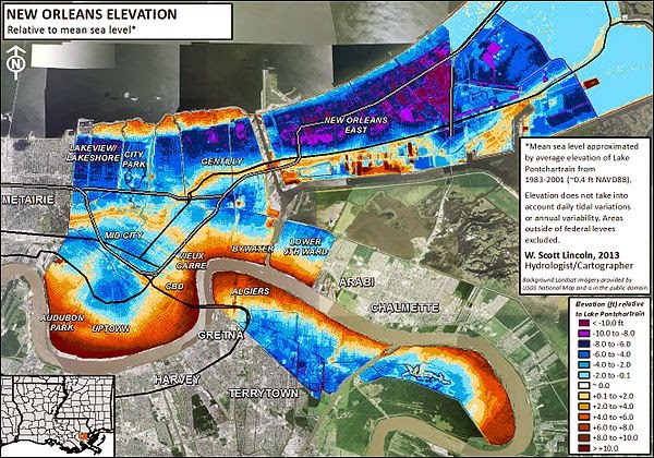
Elevation map of New Orleans. Blue/purple indicates elevations below the average level of Lake Pontchartain (1983-2001) and orange/brown indicates elevations above.
1. New Orleans is partly below sea level. Roughly half the city and surrounding metropolis is above sea level.
2. Lake Pontchartrain is named for Louis Phélypeaux, comte de Pontchartrain. He was the French Minister of the Marine, Chancellor and Controller-General of Finances during the reign of France's "Sun-King", Louis XIV. Lake Pontchartrain is not a true lake, but an estuary connected to the Gulf of Mexico. It is one of the largest wetlands along the Gulf Coast of North America.
3. The Lake Pontchartrain Causeway, is a causeway (a raised road or path that goes over wetlands or water) composed of two parallel bridges crossing Lake Pontchartrain. The longer bridge is 38.35 km long (23.83 miles). Since 1969, it was the longest bridge over water in the world. In 2011 it became the longest bridge over water (continuous) and Jiaozhou Bay Bridge in China became the longest bridge over water (aggregate).
4. The Mississippi River (See Entre 6 (D-6) March 14th)
5. New Orleans has more total mileage of canals, both above and below ground, than Venice in Italy. Canal Street, a famous street in New Orleans, was originally intended to be a canal but it was never built.
Jane
It's a sad way to end today's entry, but here's a little more music...STORMY WEATHER. Three selections for you:
https://www.youtube.com/watch?v=QCG3kJtQBKo (Lena Horne)
https://www.youtube.com/watch?v=EIgVCU19pjg (Billy Holiday)
https://www.youtube.com/watch?v=ezGHapF8-lY (Ella Fitzgerald)

No comments:
Post a Comment